Inuit user needs documented across Nunavut, Canada: Reports release key messages for polar environmental service providers
PCAPS promotes research that helps to enable improved prediction services in the polar regions, to better support human and environmental well-being. A challenge in achieving this goal is understanding user needs and the socio-psychological factors affecting decision-making, to improve services provision in the fast-changing polar regions. A YOPP-endorsed project led by Canadian PCAPS Steering Group member Dr. Gita Ljubicic, along with the Aqqiumavvik Society, recently released reports from a three-year project to learn about Inuit uses and needs for weather, water, ice, and climate information across the Territory of Nunavut, Canada.
The Nunavut-wide and 8 community-specific reports (in English and regional dialects of Inuktut) are available here.
At the ice floe edge outside Pond Inlet, Nunavut. Photo credits: Andrew Arreak.
The 50+ member Canadian team, comprising Inuit, northern, and southern researchers, surveyed 360 community members across eight communities in Nunavut. Survey questions were designed with input from team members, service providers, Inuit organizations, governments and others. The survey aimed to address community concerns that current environmental information and forecasting services are not easy to use, access, or understand. Forecasting information is not always accurate for local conditions, and increasingly unpredictable environmental conditions have made it harder and riskier for Nunavummiut (people of Nunavut) to hunt and travel safely.
Surveys were facilitated by 19 Local Research Coordinators working in their home communities. Results provide insights into community-specific:
1. travel habits;
2. environmental conditions that inform decision-making about travel safety;
3. sources of environmental information used from community and polar service providers; and
4. training interests.
Boat travel outside Iqaluit, Nunavut. Photo credits: Jason Carpenter.
Survey participants highlight that Nunavummiut travel in all seasons, mainly using snowmobiles on sea ice and land, all-terrain vehicles on land, and small boats (4-14 metres) on the ocean.
Nunavummiut travel to get out of town/go to a cabin or camp, hunt on land, in the ocean or on sea ice, fish in the ocean and lakes, gather food, or collect drinking water, among other reasons. The main weather stations are located at the community airport, but Nunavummiut often travel up to 500km from town, and so it is critical for them to assess weather, water, and ice conditions to inform travel.
Map showing extent of travel by 266 survey respondents around 7 Nunavut communities. Source: Nunavut survey results report.
Survey participants indicated the most important weather, ice, water, and other environmental conditions that they check when planning a trip. Only the top three for each are shown in the table below.
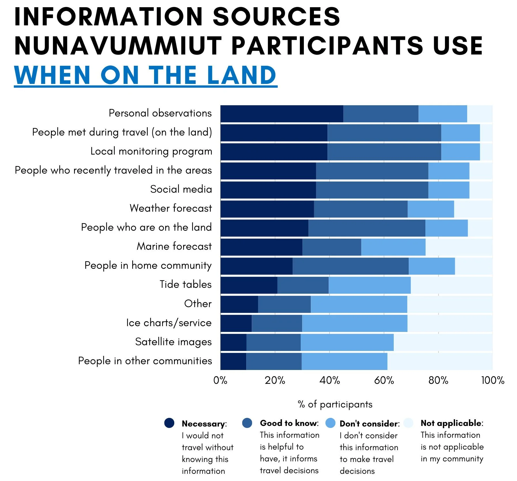
To support travel planning, participants most often combine checking the weather and marine forecast with personal observations and talking to people who recently travelled to areas of interest. However, once they are travelling (on land, water or ice), Nunavummiut need to rely on their own observations and information shared by other travellers they meet, as there is limited or no access to online weather/ice/marine products outside the community.
Source: Nunavut survey results report.
Participants who access information from regional, national, or polar service providers, do so in many ways which differed by service type - weather forecast, marine forecast, ice services, tide tables, satellite images - and by community; demonstrating that tailored modes of communication are vital for polar service providers to reach northern audiences.
Source: Nunavut survey results report.
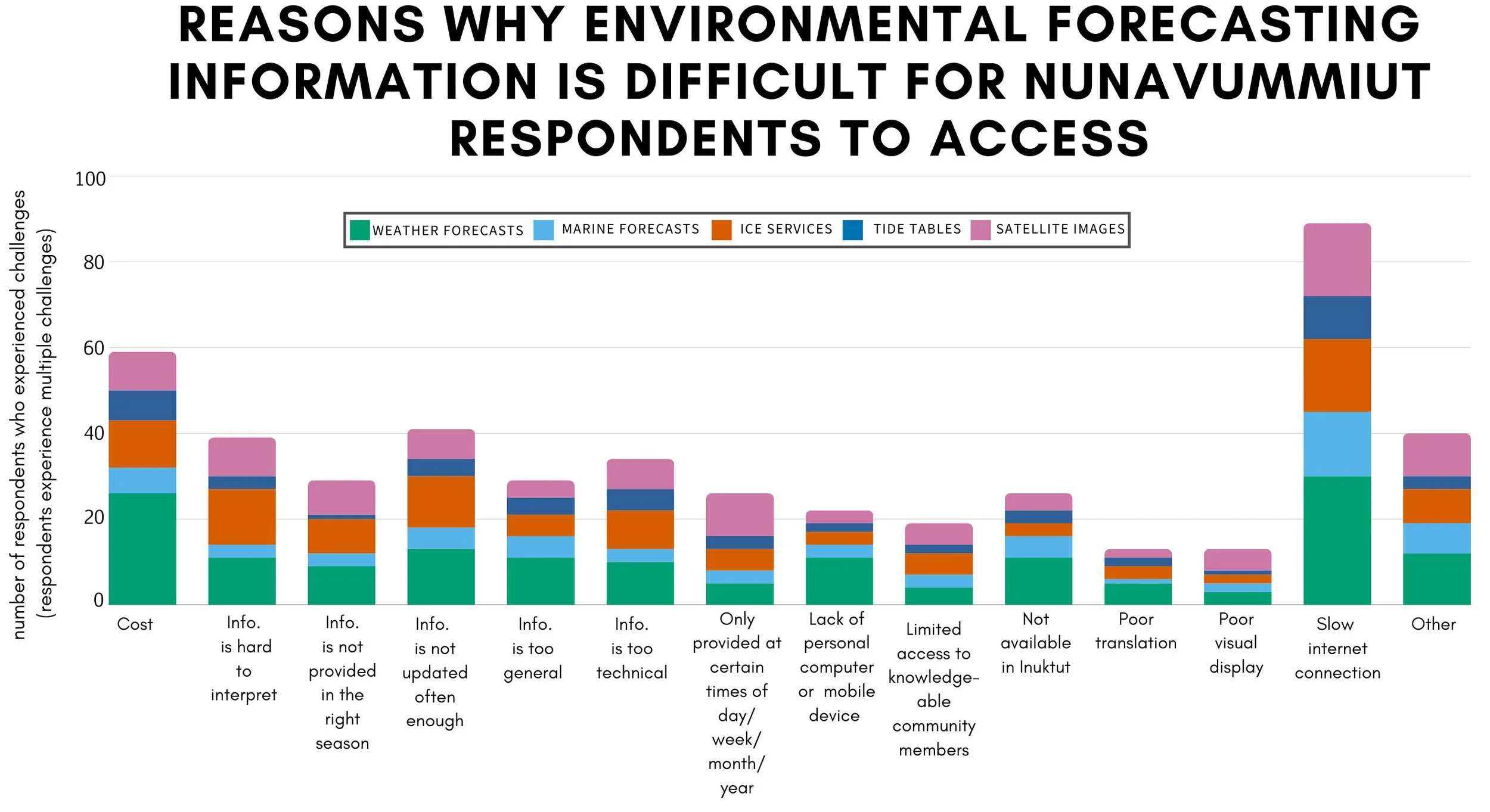
Nunavut respondents also identified several reasons why environmental forecasting information is difficult to access. Reasons varied by community, and include: slow internet connection, cost (of devices, internet access, cellular data, service subscriptions), lack of personal computer/mobile device, and information that is not updated often enough.
Source: Nunavut survey results report.
Local Research Coordinators, Elder mentors, and research partners identified action-oriented key messages for service providers that could improve infrastructure, product development, accessibility, ease of use, and relevance to better meet Nunavummiut needs.
Source: Nunavut survey results report.
Ultimately, we hope that the results of this project will lead to improved services that can help Nunavummiut travel more safely on the land. In addition, this study from Nunavut can serve as a model for PCAPS in terms of the value of partnerships to learn about user needs, which is an essential starting point to effectively tailor research and investments into polar services provision that contribute to societal well-being.
“Any effort to make environmental forecasting products more user-friendly, complete, and locally applicable is valuable—it could save lives.”
Thumbnail photo information: View of Lancaster Sound from the shores of Pond Inlet, Nunavut Photo credit: Gita Ljubicic


